Geolocate

Pinch topographic map

Click on the map to display elevation.

About this map

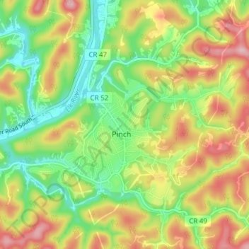
Name: Pinch topographic map, elevation, terrain.

Location: Pinch, Kanawha County, West Virginia, 25156, United States (38.39284 -81.51208 38.42824 -81.44952)

Average elevation: 255 m

Minimum elevation: 172 m

Maximum elevation: 359 m

Gear up for your next adventure:

🚑Survival Whistle - Signal for help across long distances in mountains
🥾Trekking Poles - Adjustable trekking poles to reduce knee stress and improve stability
Camping Groundsheet - Protect your tent from moisture and dirt
🐕Hiking Dog Pack - Let your canine companion carry their own water and food
🔭Compact Monocular - One-handed bird watching and trail spotting

As an Amazon Associate, this site earns from qualifying purchases at no extra cost to you.