Geolocate

Hohenrode topographic map

Click on the map to display elevation.

About this map

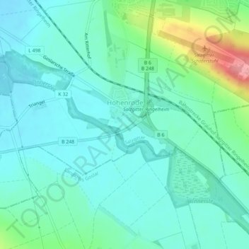
Name: Hohenrode topographic map, elevation, terrain.

Location: Hohenrode, Ortschaft Süd, Salzgitter, Lower Saxony, Germany (52.01599 10.34045 52.02858 10.36759)

Average elevation: 156 m

Minimum elevation: 133 m

Maximum elevation: 236 m

Gear up for your next adventure:

Bushcraft Tarp - Versatile emergency shelter or gear protection
🛶Kayak Dry Bag - Waterproof storage for kayaking adventures
🔥Camping Stove - Portable stoves to cook outdoors with ease
🥾Light Trekking Boots - Supportive boots for multi-day treks
Backpacking Tent - Lightweight tent for long-distance hiking trips

As an Amazon Associate, this site earns from qualifying purchases at no extra cost to you.