Geolocate

Echarati topographic map

Click on the map to display elevation.

About this map

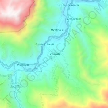
Name: Echarati topographic map, elevation, terrain.

Location: Echarati, Echarate, La Convención, Cusco, Perú (-12.78781 -72.59786 -12.74781 -72.55786)

Average elevation: 1,173 m

Minimum elevation: 871 m

Maximum elevation: 2,038 m

Gear up for your next adventure:

🧭GPS Tracker - Track your location in remote areas safely
💧Filtered Water Bottle - Safe drinking water on the go
🚲MTB Frame Bag - Carry tools and maps directly on your bicycle frame
🧥Packable Rain Jacket - Breathable waterproof layer for unpredictable weather
🧳Compression Sacks - Maximize space in your backpack by shrinking gear

As an Amazon Associate, this site earns from qualifying purchases at no extra cost to you.