
Thank you for supporting this site ❤️
Make a donation
Make a donation
Gear up for your next adventure:
As an Amazon Associate, this site earns from qualifying purchases at no extra cost to you.
Drummond topographic map
Click on the map to display elevation.
Thank you for supporting this site ❤️
Make a donation
Make a donation
Gear up for your next adventure:
As an Amazon Associate, this site earns from qualifying purchases at no extra cost to you.
About this map
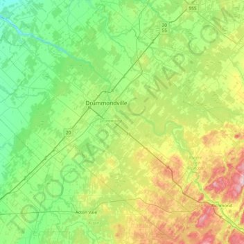
Name: Drummond topographic map, elevation, terrain.
Location: Drummond, Centre-du-Québec, Quebec, Canada (45.58941 -72.85400 46.09796 -72.09285)
Average elevation: 100 m
Minimum elevation: 4 m
Maximum elevation: 364 m
Thank you for supporting this site ❤️
Make a donation
Make a donation
Gear up for your next adventure:
As an Amazon Associate, this site earns from qualifying purchases at no extra cost to you.
Other topographic maps
Click on a map to view its topography, its elevation and its terrain.
Parc Herbert-Brown-Ames
Canada > Quebec > Urban agglomeration of Montreal > Montreal
Average elevation: 32 m