Geolocate

Jobs topographic map

Click on the map to display elevation.

About this map

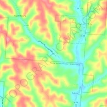
Name: Jobs topographic map, elevation, terrain.

Location: Jobs, Hocking County, Ohio, 43144, United States (39.48035 -82.19904 39.52035 -82.15904)

Average elevation: 259 m

Minimum elevation: 208 m

Maximum elevation: 308 m

Other topographic maps

Click on a map to view its topography, its elevation and its terrain.

Murray City

United States > Ohio > Hocking County

Average elevation: 257 m

Rose Lake

United States > Ohio > Hocking County

Average elevation: 295 m

Logan

United States > Ohio > Hocking County

Average elevation: 254 m

Rose Lake Dam

United States > Ohio > Hocking County

Average elevation: 297 m

Gear up for your next adventure:

🎒Hiking Backpack - Lightweight and ergonomic backpacks for day hikes or multi-day treks
🧥Thermal Fleece Jacket - Versatile insulation for changing mountain temperatures
🛶Kayak Accessories - Essential gear for safe and fun kayaking adventures
🔦LED Headtorch - Bright and durable light for night activities
🛶Waterproof Dry Bags - Keep electronics and clothes dry during river crossings

As an Amazon Associate, this site earns from qualifying purchases at no extra cost to you.