Geolocate

Kamaryut topographic map

Click on the map to display elevation.

About this map

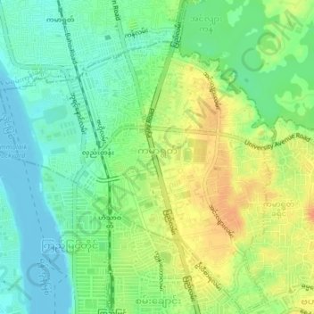
Name: Kamaryut topographic map, elevation, terrain.

Location: Kamaryut, Kamayut District, Yangon City, Yangon, Myanmar (16.80460 96.11267 16.84138 96.14635)

Average elevation: 18 m

Minimum elevation: -1 m

Maximum elevation: 40 m

Other topographic maps

Click on a map to view its topography, its elevation and its terrain.

Zee Kone

Myanmar > Yangon > Yangon City

Average elevation: 11 m

Htauk Kyant

Myanmar > Yangon > Yangon City

Average elevation: 17 m

Gear up for your next adventure:

🧊Portable Cooler - Keep food and drinks cold during outdoor adventures
🚲Bike Repair Kit - Essential tools for on-trail mechanical issues
🧭GPS Outdoor Watch - Smart watch for navigation and fitness tracking in nature
🔪Outdoor Multitool - Versatile tool for repairs and food prep in the wild
🛰️Satellite Messenger - Emergency communication for areas with no cell service

As an Amazon Associate, this site earns from qualifying purchases at no extra cost to you.