
Make a donation
Gear up for your next adventure:
As an Amazon Associate, this site earns from qualifying purchases at no extra cost to you.
Meixide topographic map
Click on the map to display elevation.
Make a donation
Gear up for your next adventure:
As an Amazon Associate, this site earns from qualifying purchases at no extra cost to you.
About this map
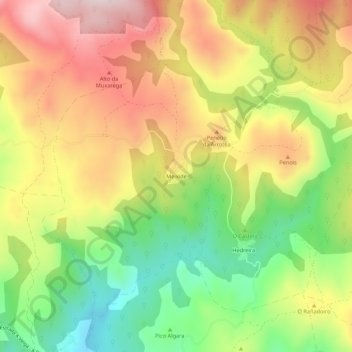
Name: Meixide topographic map, elevation, terrain.
Location: Meixide, La Vega, Valdeorras, Orense, Galicia, 32366, España (42.25241 -6.95199 42.29241 -6.91199)
Average elevation: 1,171 m
Minimum elevation: 957 m
Maximum elevation: 1,387 m
Make a donation
Gear up for your next adventure:
As an Amazon Associate, this site earns from qualifying purchases at no extra cost to you.
Other topographic maps
Click on a map to view its topography, its elevation and its terrain.
Prada
España > Galicia > Valdeorras > La Vega
Al sur, el embalse (altitud media 861 m y bajo sus aguas la antigua parroquia y lugar de Alberguería que estaba a 817 m) y a 11 km por carretera, la capital del municipio, La Vega.
Average elevation: 1,075 m
Make a donation
Gear up for your next adventure:
As an Amazon Associate, this site earns from qualifying purchases at no extra cost to you.