Geolocate

Champagne crayeuse topographic map

Click on the map to display elevation.

About this map

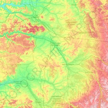
Name: Champagne crayeuse topographic map, elevation, terrain.

Location: Champagne crayeuse, Grand Est, Metropolitan France, France (48.22833 3.08174 49.44928 4.82231)

Average elevation: 163 m

Minimum elevation: 42 m

Maximum elevation: 405 m

Other topographic maps

Click on a map to view its topography, its elevation and its terrain.

Crave

France > Grand Est > Moselle > Bezange-la-Petite

Average elevation: 225 m

La Nied Française

France > Grand Est > Moselle

Average elevation: 254 m

Mont Sainte-Odile

France > Grand Est > Bas-Rhin > Ottrott

Average elevation: 599 m

Sausteig

France > Grand Est > Bas-Rhin > Obermodern-Zutzendorf

Average elevation: 189 m

La Corrée

France > Grand Est > Blessonville

Average elevation: 282 m

Les Rangs

France > Grand Est > Vosges > Éloyes > Les Rangs

Average elevation: 466 m

Le Gramp le Loup

France > Grand Est > Marne > Dommartin-Varimont

Average elevation: 184 m

Reims

France > Grand Est > Marne > Reims

Average elevation: 130 m

Praque

France > Grand Est > Meurthe-et-Moselle > Jouaville

Average elevation: 256 m

Gear up for your next adventure:

🦶Hiking Shoe Insoles - Added support for high arches and long days on feet
🧥Softshell Hiking Jacket - The perfect balance of wind protection and breathability
🥾Trail Hiking Shoes - Durable shoes designed for rugged trails
👟Sport Hiking Sandals - Breathable footwear for water crossings and camp rest
🥾All-Terrain Hiking Boots - Versatile boots for varied hiking conditions

As an Amazon Associate, this site earns from qualifying purchases at no extra cost to you.