Geolocate

15100 topographic map

Click on the map to display elevation.

About this map

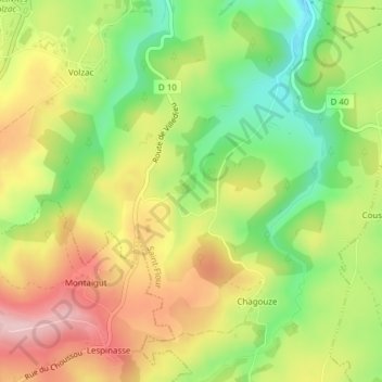
Name: 15100 topographic map, elevation, terrain.

Location: 15100, Saint-Flour, Cantal, Auvergne-Rhône-Alpes, France métropolitaine, France (44.91660 2.94317 45.11286 3.31488)

Average elevation: 951 m

Minimum elevation: 639 m

Maximum elevation: 1,369 m

Other topographic maps

Click on a map to view its topography, its elevation and its terrain.

Bel-Air

France > Auvergne-Rhône-Alpes > Cantal > Saint-Flour

Average elevation: 848 m

Fraissinet

France > Auvergne-Rhône-Alpes > Cantal > Saint-Flour

Average elevation: 949 m

Le Fayet

France > Auvergne-Rhône-Alpes > Cantal > Saint-Flour

Average elevation: 928 m

Pitot

France > Auvergne-Rhône-Alpes > Cantal > Saint-Flour

Average elevation: 856 m

Mourelle

France > Auvergne-Rhône-Alpes > Cantal > Saint-Flour

Average elevation: 928 m

Gear up for your next adventure:

🛏️Camping Sleeping Mat - Comfortable mats for sleeping outdoors
🚑Survival Whistle - Signal for help across long distances in mountains
🥾Waterproof Hiking Shoes - Durable shoes for wet and rugged trails
🛌Down Sleeping Bag - Superior warmth-to-weight ratio for cold nights
🔦LED Flashlight - Powerful and long-lasting flashlight for camping and emergencies

As an Amazon Associate, this site earns from qualifying purchases at no extra cost to you.