
Make a donation
Gear up for your next adventure:
As an Amazon Associate, this site earns from qualifying purchases at no extra cost to you.
Holzhausen topographic map
Click on the map to display elevation.
Make a donation
Gear up for your next adventure:
As an Amazon Associate, this site earns from qualifying purchases at no extra cost to you.
About this map
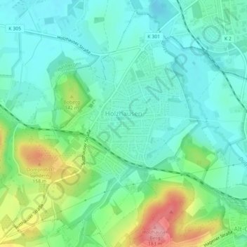
Name: Holzhausen topographic map, elevation, terrain.
Average elevation: 100 m
Minimum elevation: 67 m
Maximum elevation: 185 m
Make a donation
Gear up for your next adventure:
As an Amazon Associate, this site earns from qualifying purchases at no extra cost to you.
Other topographic maps
Click on a map to view its topography, its elevation and its terrain.
Kloster Oesede
Deutschland > Niedersachsen > Landkreis Osnabrück > Georgsmarienhütte > Kloster Oesede
Average elevation: 125 m
Harderberg
Deutschland > Niedersachsen > Landkreis Osnabrück > Georgsmarienhütte > Harderberg
Average elevation: 116 m
Dörenberg
Deutschland > Niedersachsen > Landkreis Osnabrück > Georgsmarienhütte
Average elevation: 200 m
Lammersbrink
Deutschland > Niedersachsen > Landkreis Osnabrück > Georgsmarienhütte
Average elevation: 154 m
Make a donation
Gear up for your next adventure:
As an Amazon Associate, this site earns from qualifying purchases at no extra cost to you.
Dörenberg
Deutschland > Niedersachsen > Landkreis Osnabrück > Georgsmarienhütte
Average elevation: 200 m