Geolocate

Kundrathur topographic map

Click on the map to display elevation.

About this map

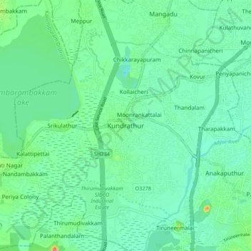
Name: Kundrathur topographic map, elevation, terrain.

Location: Kundrathur, Pallavaram, Chengalpattu, Tamil Nadu, 600069, India (12.95577 80.05731 13.03577 80.13731)

Average elevation: 20 m

Minimum elevation: 1 m

Maximum elevation: 81 m

Other topographic maps

Click on a map to view its topography, its elevation and its terrain.

Adyar River

India > Tamil Nadu > Pallavaram

Average elevation: 22 m

Keelkatalai Lake

India > Tamil Nadu > Pallavaram

Average elevation: 11 m

Keelkatalai Lake

India > Tamil Nadu > Pallavaram

Average elevation: 11 m

Gear up for your next adventure:

🦶Anti-Blister Balm - Prevents friction and hotspots during long ascents
Lightweight Camping Tent - Portable shelter optimized for Canadian backcountry camping
🥾Hiking Shoes - Durable and comfortable shoes for trail hiking
🥤Collapsible Travel Cup - Saves space and weight in your mess kit
🧦Hiking Liner Socks - Thin base layer to prevent friction and blisters

As an Amazon Associate, this site earns from qualifying purchases at no extra cost to you.