Geolocate

Sempur topographic map

Click on the map to display elevation.

About this map

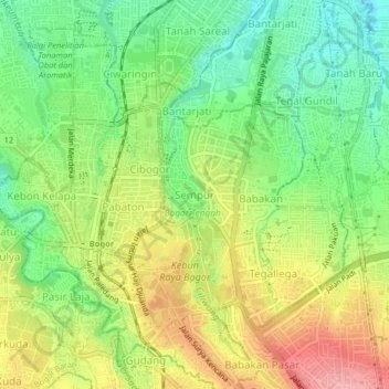
Name: Sempur topographic map, elevation, terrain.

Location: Sempur, Bogor, West Java, Java, 16128, Indonesia (-6.61036 106.78040 -6.57036 106.82040)

Average elevation: 242 m

Minimum elevation: 187 m

Maximum elevation: 310 m

Other topographic maps

Click on a map to view its topography, its elevation and its terrain.

Bogor Selatan

Indonesia > West Java > Bogor

Average elevation: 377 m

Bogor Timur

Indonesia > West Java > Bogor

Average elevation: 329 m

Tanah Sareal

Indonesia > West Java > Bogor

Average elevation: 182 m

Tanah Sareal

Indonesia > West Java > Bogor

Average elevation: 215 m

Bogor Barat

Indonesia > West Java > Bogor

Average elevation: 215 m

Ciomas

Indonesia > West Java > Bogor

Average elevation: 230 m

Gear up for your next adventure:

🚲Handlebar Phone Mount - View topographic-map.com live while cycling
🥾Durable Hiking Shoes - Long-lasting shoes for frequent hiking
Backpacking Tent - Lightweight tent for long-distance hiking trips
🧦Outdoor Socks - Durable socks designed for hiking and outdoor sports
🧥Softshell Hiking Jacket - The perfect balance of wind protection and breathability

As an Amazon Associate, this site earns from qualifying purchases at no extra cost to you.