Geolocate

Gefrees topographic map

Click on the map to display elevation.

About this map

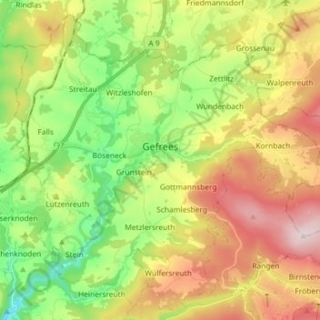
Name: Gefrees topographic map, elevation, terrain.

Location: Gefrees, Landkreis Bayreuth, Bavaria, 95482, Germany (50.04970 11.67457 50.13393 11.81840)

Average elevation: 585 m

Minimum elevation: 384 m

Maximum elevation: 851 m

Other topographic maps

Click on a map to view its topography, its elevation and its terrain.

Bindlacher Berg

Germany > Bavaria > Landkreis Bayreuth > Bindlach

Average elevation: 426 m

Weidensees

Germany > Bavaria > Landkreis Bayreuth > Betzenstein

Average elevation: 469 m

Trockau

Germany > Bavaria > Landkreis Bayreuth > Pegnitz

Average elevation: 501 m

Gear up for your next adventure:

🥾Light Hiking Boots - Lightweight and comfortable boots for day hikes
🧊Portable Cooler - Keep food and drinks cold during outdoor adventures
🥾Waterproof Hiking Boots - Boots keeping your feet dry in wet conditions
📷Outdoor Action Camera - Capture high-elevation views and rugged adventures
👟Trail Running Shoes - Agile footwear for fast-paced topographic exploration

As an Amazon Associate, this site earns from qualifying purchases at no extra cost to you.