
Make a donation
Gear up for your next adventure:
As an Amazon Associate, this site earns from qualifying purchases at no extra cost to you.
Ivăneasa topographic map
Click on the map to display elevation.
Make a donation
Gear up for your next adventure:
As an Amazon Associate, this site earns from qualifying purchases at no extra cost to you.
About this map
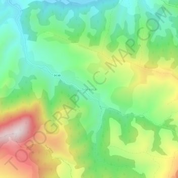
Name: Ivăneasa topographic map, elevation, terrain.
Location: Ivăneasa, Ilva Mare, Bistrița-Năsăud, 427091, Romania (47.31878 24.88850 47.35878 24.92850)
Average elevation: 868 m
Minimum elevation: 617 m
Maximum elevation: 1,289 m
Make a donation
Gear up for your next adventure:
As an Amazon Associate, this site earns from qualifying purchases at no extra cost to you.
Other topographic maps
Click on a map to view its topography, its elevation and its terrain.
Bistrița
According to Köppen climate classification, Bistrița has a humid continental climate(Dfb) with cold, snowy winters and warm, rainy summers. Due to its modest elevation, Bistrița has one of the coldest climates in Romania.
Average elevation: 429 m
Make a donation
Gear up for your next adventure:
As an Amazon Associate, this site earns from qualifying purchases at no extra cost to you.
Bistrița
According to Köppen climate classification, Bistrița has a humid continental climate(Dfb) with cold, snowy winters and warm, rainy summers. Due to its modest elevation, Bistrița has one of the coldest climates in Romania.
Average elevation: 429 m
Bistrița
Due to its modest elevation, Bistrița has one of the coldest climates in Romania.
Average elevation: 429 m
Make a donation
Gear up for your next adventure:
As an Amazon Associate, this site earns from qualifying purchases at no extra cost to you.
Make a donation
Gear up for your next adventure:
As an Amazon Associate, this site earns from qualifying purchases at no extra cost to you.
Make a donation
Gear up for your next adventure:
As an Amazon Associate, this site earns from qualifying purchases at no extra cost to you.