
Louveigné topographic map
Interactive map
Click on the map to display elevation.
About this map
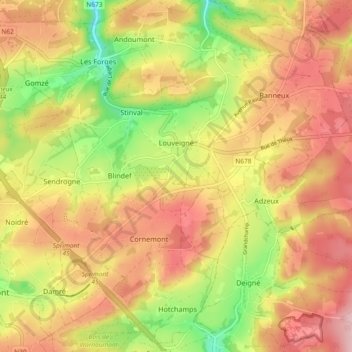
Name: Louveigné topographic map, elevation, terrain.
Location: Louveigné, Sprimont, Luik, Wallonië, 4141, België (50.49555 5.67138 50.55435 5.76308)
Average elevation: 269 m
Minimum elevation: 155 m
Maximum elevation: 367 m
Other topographic maps
Click on a map to view its topography, its elevation and its terrain.
Dolembreux
Dolembreux, Sprimont, Luik, Wallonië, 4140, België
Average elevation: 237 m