
Thank you for supporting this site ❤️
Make a donation
Make a donation
Gear up for your next adventure:
As an Amazon Associate, this site earns from qualifying purchases at no extra cost to you.
Rykkinn topographic map
Click on the map to display elevation.
Thank you for supporting this site ❤️
Make a donation
Make a donation
Gear up for your next adventure:
As an Amazon Associate, this site earns from qualifying purchases at no extra cost to you.
About this map
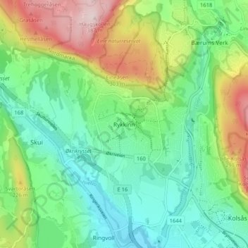
Name: Rykkinn topographic map, elevation, terrain.
Location: Rykkinn, Bærum, Akershus, 1349, Norway (59.90874 10.45531 59.94874 10.49531)
Average elevation: 138 m
Minimum elevation: 21 m
Maximum elevation: 380 m
Thank you for supporting this site ❤️
Make a donation
Make a donation
Gear up for your next adventure:
As an Amazon Associate, this site earns from qualifying purchases at no extra cost to you.