
Aube topographic map
Interactive map
Click on the map to display elevation.
About this map
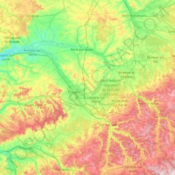
Name: Aube topographic map, elevation, terrain.
Location: Aube, Grande Leste, França metropolitana, França (47.92350 3.38364 48.71672 4.86513)
Average elevation: 174 m
Minimum elevation: 58 m
Maximum elevation: 418 m
Other topographic maps
Click on a map to view its topography, its elevation and its terrain.
Mont Cep
França > Grande Leste > Aube > Bouilly
Mont Cep, Bouilly, Troyes, Aube, Grande Leste, França metropolitana, 10320, França
Average elevation: 203 m