
Make a donation
Gear up for your next adventure:
As an Amazon Associate, this site earns from qualifying purchases at no extra cost to you.
Chastre topographic map
Click on the map to display elevation.
Make a donation
Gear up for your next adventure:
As an Amazon Associate, this site earns from qualifying purchases at no extra cost to you.
Chastre
Located between Ottignies-Louvain-la-Neuve and Gembloux, 40 km from Brussels, Chastre is well served by road and railway networks. A small river called the Orne passes right through Chastre. With its tributaries, the Orne creates enchanting landscapes, surrounding magnificent farmhouses, often still fully in use. Chastre's highest point has an elevation of 165 metres. The municipality is twinned with Lespignan, Hérault department, France (since 1998) and Saint-Denis-sur-Richelieu, Canada.
Make a donation
Gear up for your next adventure:
As an Amazon Associate, this site earns from qualifying purchases at no extra cost to you.
About this map
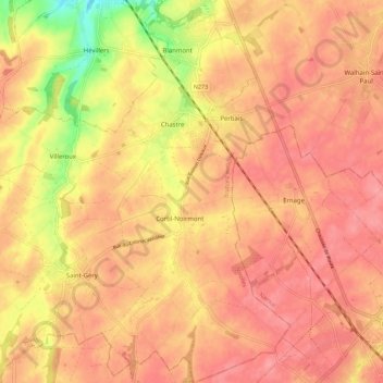
Name: Chastre topographic map, elevation, terrain.
Location: Chastre, Nivelles, Walloon Brabant, Wallonia, 1450, Belgium (50.56023 4.57330 50.63126 4.67304)
Average elevation: 146 m
Minimum elevation: 90 m
Maximum elevation: 169 m
Make a donation
Gear up for your next adventure:
As an Amazon Associate, this site earns from qualifying purchases at no extra cost to you.