
Thank you for supporting this site ❤️
Make a donation
Make a donation
Gear up for your next adventure:
As an Amazon Associate, this site earns from qualifying purchases at no extra cost to you.
Chacapampa topographic map
Click on the map to display elevation.
Thank you for supporting this site ❤️
Make a donation
Make a donation
Gear up for your next adventure:
As an Amazon Associate, this site earns from qualifying purchases at no extra cost to you.
About this map
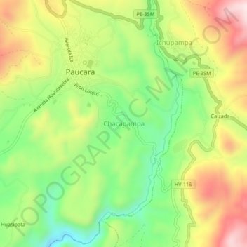
Name: Chacapampa topographic map, elevation, terrain.
Location: Chacapampa, Paucará, Acobamba, Huancavelica, Perú (-12.75830 -74.67898 -12.71830 -74.63898)
Average elevation: 3,800 m
Minimum elevation: 3,588 m
Maximum elevation: 4,057 m
Thank you for supporting this site ❤️
Make a donation
Make a donation
Gear up for your next adventure:
As an Amazon Associate, this site earns from qualifying purchases at no extra cost to you.