
Make a donation
Gear up for your next adventure:
As an Amazon Associate, this site earns from qualifying purchases at no extra cost to you.
Tielen topographic map
Click on the map to display elevation.
Make a donation
Gear up for your next adventure:
As an Amazon Associate, this site earns from qualifying purchases at no extra cost to you.
Tielen
Tielen ligt op een hoogte van 15-22 meter in de Kempen. Belangrijke waterlopen zijn de Grote Kaliebeek in het zuiden en de Aa in het noorden, die ook de Kaliebeek opneemt en vervolgens in westelijke richting naar de Kleine Nete stroomt. Het natuurreservaat de Balderij, met het Rielens Gebroekt, ligt aan de samenvloeiing van Grote en Kleine Kaliebeek. Daarnaast zijn er nog het natuurgebied Winkelsbroek en de Tielenheide.
Make a donation
Gear up for your next adventure:
As an Amazon Associate, this site earns from qualifying purchases at no extra cost to you.
About this map
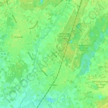
Name: Tielen topographic map, elevation, terrain.
Location: Tielen, Kasterlee, Turnhout, Antwerpen, Vlaanderen, België (51.23028 4.86178 51.28690 4.93391)
Average elevation: 16 m
Minimum elevation: 8 m
Maximum elevation: 24 m
Make a donation
Gear up for your next adventure:
As an Amazon Associate, this site earns from qualifying purchases at no extra cost to you.
Other topographic maps
Click on a map to view its topography, its elevation and its terrain.
Heuvelrug tussen Lichtaart en Kasterlee
België > Antwerpen > Turnhout > Kasterlee
Average elevation: 17 m