Geolocate

Yangyun topographic map

Click on the map to display elevation.

About this map

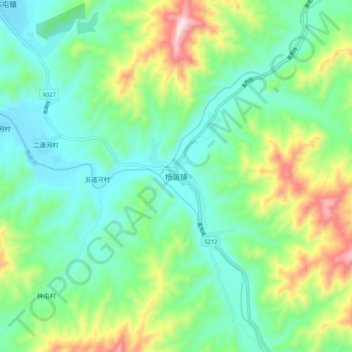
Name: Yangyun topographic map, elevation, terrain.

Location: Yangyun, Yingkou City, Liaoning, China (40.05813 122.20900 40.13813 122.28900)

Average elevation: 208 m

Minimum elevation: 44 m

Maximum elevation: 612 m

Gear up for your next adventure:

🧴Waterproofing Spray - Restore the DWR coating on jackets and tents
🔦LED Headtorch - Bright and durable light for night activities
🧭Orienteering Kit - Tools for map reading and navigation in the wild
🚲MTB Frame Bag - Carry tools and maps directly on your bicycle frame
🥾All-Terrain Hiking Boots - Versatile boots for varied hiking conditions

As an Amazon Associate, this site earns from qualifying purchases at no extra cost to you.