
Kenmare Municipal District topographic map
Interactive map
Click on the map to display elevation.
About this map
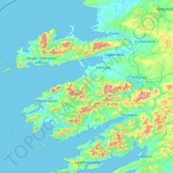
Name: Kenmare Municipal District topographic map, elevation, terrain.
Location: Kenmare Municipal District, Comté de Kerry, Munster, Irlande (51.68820 -10.61844 52.33778 -9.27401)
Average elevation: 98 m
Minimum elevation: -3 m
Maximum elevation: 1,001 m
Other topographic maps
Click on a map to view its topography, its elevation and its terrain.
Dingle / Daingean Uí Chúis
Dingle / Daingean Uí Chúis, Comté de Kerry, Munster, Irlande
Average elevation: 41 m
Tralee Municipal District
Tralee Municipal District, Comté de Kerry, Munster, Irlande
Average elevation: 111 m
Ladies View
Ladies View, N71, Muckross ED, Killarney Municipal District, Comté de Kerry, Munster, Irlande
Average elevation: 130 m
Lee
Irlande > Comté de Kerry > Tralee
Lee, Tralee Rural ED, Tralee, Comté de Kerry, Munster, V92 DE28, Irlande
Average elevation: 9 m
Dingle
Dingle, Kenmare Municipal District, Comté de Kerry, Munster, Irlande
Average elevation: 121 m