
Thank you for supporting this site ❤️
Make a donation
Make a donation
Gear up for your next adventure:
As an Amazon Associate, this site earns from qualifying purchases at no extra cost to you.
Andrijevica topographic map
Click on the map to display elevation.
Thank you for supporting this site ❤️
Make a donation
Make a donation
Gear up for your next adventure:
As an Amazon Associate, this site earns from qualifying purchases at no extra cost to you.
About this map
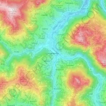
Name: Andrijevica topographic map, elevation, terrain.
Location: Andrijevica, Andrijevica Municipality, 84320, Montenegro (42.69396 19.75179 42.77396 19.83179)
Average elevation: 1,068 m
Minimum elevation: 708 m
Maximum elevation: 1,641 m
Thank you for supporting this site ❤️
Make a donation
Make a donation
Gear up for your next adventure:
As an Amazon Associate, this site earns from qualifying purchases at no extra cost to you.