
Make a donation
Gear up for your next adventure:
As an Amazon Associate, this site earns from qualifying purchases at no extra cost to you.
Meyernberg topographic map
Click on the map to display elevation.
Make a donation
Gear up for your next adventure:
As an Amazon Associate, this site earns from qualifying purchases at no extra cost to you.
About this map
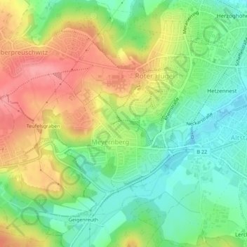
Name: Meyernberg topographic map, elevation, terrain.
Location: Meyernberg, Bayreuth, Bayern, Deutschland (49.93002 11.52202 49.94777 11.54867)
Average elevation: 382 m
Minimum elevation: 340 m
Maximum elevation: 436 m
Make a donation
Gear up for your next adventure:
As an Amazon Associate, this site earns from qualifying purchases at no extra cost to you.
Other topographic maps
Click on a map to view its topography, its elevation and its terrain.
Bayreuth
Deutschland > Bayern > Bayreuth
Das Zentrum der Stadt (nicht zu verwechseln mit dem dezentral gelegenen Stadtteil Altstadt) liegt mit etwa 340 Meter über NN mehr als 100 Meter tiefer als die meisten der Höhenzüge, die den Bayreuther Talkessel einrahmen. Die Keimzelle Bayreuths am heutigen unteren Markt entstand strategisch günstig auf…
Average elevation: 377 m
Make a donation
Gear up for your next adventure:
As an Amazon Associate, this site earns from qualifying purchases at no extra cost to you.
Oberpreuschwitz
Deutschland > Bayern > Bayreuth
Aichig | Altstadt* | Bauerngrün | Bauernhöfen | Bayreuth (Historische Innenstadt) | Birken* | Bodenmühle | Burg* | Bürgerreuth* (Grüner Hügel) | Colmdorf | Destuben | Dörnhof | Dürschnitz* | Eichelberg | Eremitage | Eremitenhof | Frankengut | Friedrichsthal | Fürsetz | Gartenstadt* | Geiersnest |…
Average elevation: 389 m