Geolocate

Marbach LU topographic map

Click on the map to display elevation.

About this map

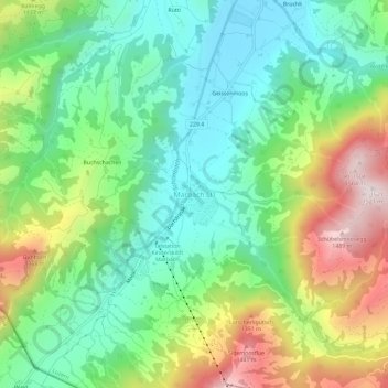
Name: Marbach LU topographic map, elevation, terrain.

Location: Marbach LU, Escholzmatt-Marbach, Lucerne, 6196, Suisse (46.83494 7.88120 46.87494 7.92120)

Average elevation: 1,056 m

Minimum elevation: 819 m

Maximum elevation: 1,499 m

Gear up for your next adventure:

🥫Freeze-Dried Meals - Lightweight, high-calorie nutrition for multi-day treks
🕯️Camping Lantern - Illuminates your entire campsite with high-efficiency LEDs
Family Camping Tent - Spacious tent suitable for family camping trips
🛌Down Sleeping Bag - Superior warmth-to-weight ratio for cold nights
🩹Compact First Aid Kit - Pre-packed essentials for common trail injuries

As an Amazon Associate, this site earns from qualifying purchases at no extra cost to you.