Geolocate

Chiclin topographic map

Click on the map to display elevation.

About this map

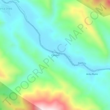
Name: Chiclin topographic map, elevation, terrain.

Location: Chiclin, Huicungo, Mariscal Cáceres, San Martín, Perú (-7.36918 -76.90111 -7.32918 -76.86111)

Average elevation: 463 m

Minimum elevation: 301 m

Maximum elevation: 884 m

Gear up for your next adventure:

🥾Trail Running Shoes - Lightweight and durable shoes for trail running
🔭Compact Monocular - One-handed bird watching and trail spotting
🛶Canoe Life Vest - Safety vest for water sports
🧼Biodegradable Camp Soap - Environmentally friendly cleaning for gear and body
🦟Insect Repellent - Keep mosquitoes and black flies away in wooded areas

As an Amazon Associate, this site earns from qualifying purchases at no extra cost to you.