Geolocate

Champ Fagou topographic map

Click on the map to display elevation.

About this map
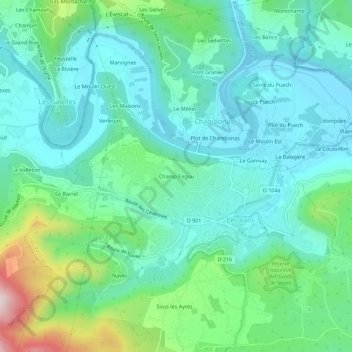
Name: Champ Fagou topographic map, elevation, terrain.

Location: Champ Fagou, Les Vans, Largentière, Ardèche, Auvergne-Rhône-Alpes, France métropolitaine, 07140, France (44.39044 4.10305 44.43044 4.14305)

Average elevation: 242 m

Minimum elevation: 132 m

Maximum elevation: 613 m

Other topographic maps

Click on a map to view its topography, its elevation and its terrain.
Naves

France > Auvergne-Rhône-Alpes > Ardèche > Les Vans

Average elevation: 275 m

Brahic

France > Auvergne-Rhône-Alpes > Ardèche > Les Vans

Average elevation: 452 m

Gear up for your next adventure:

🧢Hiking Sun Hat - Wide-brimmed protection for exposed mountain ridges
🦯Trekking Poles - Reduced impact on joints for steep topographic climbs
🧢Sun Hat - Wide-brim hat for sun protection
☕Camping Coffee Maker - Brew fresh coffee anywhere on the topographic map
🛌Down Sleeping Bag - Superior warmth-to-weight ratio for cold nights

As an Amazon Associate, this site earns from qualifying purchases at no extra cost to you.