Geolocate

Utiac topographic map

Click on the map to display elevation.

About this map

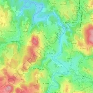
Name: Utiac topographic map, elevation, terrain.

Location: Utiac, Tence, Yssingeaux, Haute-Loire, Auvergne-Rhône-Alpes, France métropolitaine, 43190, France (45.10666 4.25375 45.14666 4.29375)

Average elevation: 875 m

Minimum elevation: 808 m

Maximum elevation: 969 m

Other topographic maps

Click on a map to view its topography, its elevation and its terrain.

Gear up for your next adventure:

Camping Tent - Weather-resistant tents suitable for 2 to 6 people
🧥Fleece Jacket - Warm and lightweight jacket for layering
🧢Hiking Hat - Sun-protective and breathable hats for long treks
🧥Packable Rain Jacket - Breathable waterproof layer for unpredictable weather
🥾Approach Shoes - Shoes designed for climbing approaches and rugged trails

As an Amazon Associate, this site earns from qualifying purchases at no extra cost to you.