
Thank you for supporting this site ❤️
Make a donation
Make a donation
Gear up for your next adventure:
As an Amazon Associate, this site earns from qualifying purchases at no extra cost to you.
Bassersdorf topographic map
Click on the map to display elevation.
Thank you for supporting this site ❤️
Make a donation
Make a donation
Gear up for your next adventure:
As an Amazon Associate, this site earns from qualifying purchases at no extra cost to you.
About this map
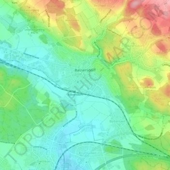
Name: Bassersdorf topographic map, elevation, terrain.
Location: Bassersdorf, Bezirk Bülach, Zurich, 8303, Switzerland (47.42028 8.60305 47.45989 8.66137)
Average elevation: 487 m
Minimum elevation: 436 m
Maximum elevation: 583 m
Thank you for supporting this site ❤️
Make a donation
Make a donation
Gear up for your next adventure:
As an Amazon Associate, this site earns from qualifying purchases at no extra cost to you.