Geolocate

Pore topographic map

Click on the map to display elevation.

About this map

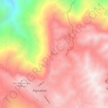
Name: Pore topographic map, elevation, terrain.

Location: Pore, Aguadas, Norte, Caldas, RAP Eje Cafetero, Colombia (5.60665 -75.47226 5.64665 -75.43226)

Average elevation: 1,933 m

Minimum elevation: 1,111 m

Maximum elevation: 2,300 m

Gear up for your next adventure:

🔥Camping Stove - Portable stoves to cook outdoors with ease
🛁Quick-Dry Microfiber Towel - Space-saving towel that dries rapidly on the move
🔋Solar Power Bank - Keep your GPS and devices charged during long outdoor trips
🥾Hiking Shoes - Durable and comfortable shoes for trail hiking
🧴Insect Repellent - Protect yourself from bugs during outdoor adventures

As an Amazon Associate, this site earns from qualifying purchases at no extra cost to you.