
Make a donation
Gear up for your next adventure:
As an Amazon Associate, this site earns from qualifying purchases at no extra cost to you.
Esclos topographic map
Click on the map to display elevation.
Make a donation
Gear up for your next adventure:
As an Amazon Associate, this site earns from qualifying purchases at no extra cost to you.
About this map
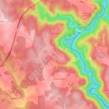
Name: Esclos topographic map, elevation, terrain.
Average elevation: 726 m
Minimum elevation: 582 m
Maximum elevation: 786 m
Make a donation
Gear up for your next adventure:
As an Amazon Associate, this site earns from qualifying purchases at no extra cost to you.
Other topographic maps
Click on a map to view its topography, its elevation and its terrain.
Le Dognon
France > Nouvelle-Aquitaine > Corrèze > Saint-Étienne-aux-Clos
Le Dognon prend sa source à 786 m d'altitude dans la Corrèze, sur la commune d'Aix, entre les lieux-dits le Marais et Laboucheix, près de trois kilomètres au nord du village d'Aix. Il forme une série d'étangs successifs puis passe sous la route départementale (RD) 49, sous la ligne ferroviaire du Palais…
Average elevation: 721 m