Geolocate

Chaparral topographic map

Click on the map to display elevation.

About this map

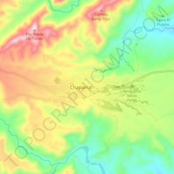
Name: Chaparral topographic map, elevation, terrain.

Location: Chaparral, Sur, Tolima, 73168, Colombia (3.68459 -75.52516 3.76459 -75.44516)

Average elevation: 794 m

Minimum elevation: 567 m

Maximum elevation: 1,115 m

Gear up for your next adventure:

🦶Anti-Blister Balm - Prevents friction and hotspots during long ascents
🥾Mountain Trail Shoes - High-traction shoes for mountain trails
🧥Fleece Jacket - Warm and lightweight jacket for layering
🛶Waterproof Dry Bags - Keep electronics and clothes dry during river crossings
🧥Softshell Jacket - Windproof and breathable jacket for hiking

As an Amazon Associate, this site earns from qualifying purchases at no extra cost to you.