
Tso Kar topographic map
Interactive map
Click on the map to display elevation.
About this map
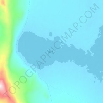
Name: Tso Kar topographic map, elevation, terrain.
Location: Tso Kar, Leh District, Jammu and Kashmir, India (33.29087 77.95251 33.33294 78.03603)
Average elevation: 4,618 m
Minimum elevation: 4,532 m
Maximum elevation: 5,390 m
Other topographic maps
Click on a map to view its topography, its elevation and its terrain.
Kishtwar
Kishtwar, Jammu and Kashmir, 182204, India
Average elevation: 3,729 m
Sonamarg
India > Jammu and Kashmir > Sonamarg
Sonamarg, Ganderbal, Jammu and Kashmir, India
Average elevation: 3,354 m
Shey
India > Jammu and Kashmir > Shey
Shey, Leh District, Jammu and Kashmir, 194201, India
Average elevation: 3,282 m
Udhampur
India > Jammu and Kashmir > Udhampur
Udhampur, Rajauri, Jammu and Kashmir, 182101, India
Average elevation: 725 m