
Make a donation
Gear up for your next adventure:
As an Amazon Associate, this site earns from qualifying purchases at no extra cost to you.
Hochheim topographic map
Click on the map to display elevation.
Make a donation
Gear up for your next adventure:
As an Amazon Associate, this site earns from qualifying purchases at no extra cost to you.
Hochheim
Im nördlichen Teil des Gothaer Landes, im Städte-Dreieck zwischen Gotha, Bad Langensalza und Erfurt, befindet sich im fruchtbaren Nessetal die Gemeinde Hochheim. Der Ort liegt nahe der Bundesstraße 247 an den südlichen Ausläufern des Hainichs in etwa 269 bis 290 m Höhe ü. NN. Die Nachbarorte sind im Süden Goldbach, Westhausen im Osten, Wangenheim im Westen und Wiegleben im Norden.
Make a donation
Gear up for your next adventure:
As an Amazon Associate, this site earns from qualifying purchases at no extra cost to you.
About this map
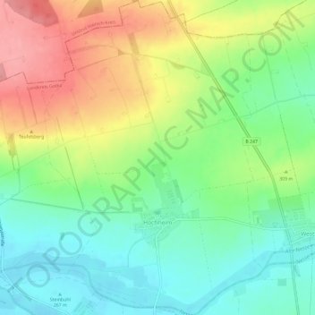
Name: Hochheim topographic map, elevation, terrain.
Location: Hochheim, Nessetal, Landkreis Gotha, Thüringen, Deutschland (51.00570 10.63856 51.04261 10.67943)
Average elevation: 299 m
Minimum elevation: 259 m
Maximum elevation: 358 m
Make a donation
Gear up for your next adventure:
As an Amazon Associate, this site earns from qualifying purchases at no extra cost to you.