
Thank you for supporting this site ❤️
Make a donation
Make a donation
Gear up for your next adventure:
As an Amazon Associate, this site earns from qualifying purchases at no extra cost to you.
Pulosari topographic map
Click on the map to display elevation.
Thank you for supporting this site ❤️
Make a donation
Make a donation
Gear up for your next adventure:
As an Amazon Associate, this site earns from qualifying purchases at no extra cost to you.
About this map
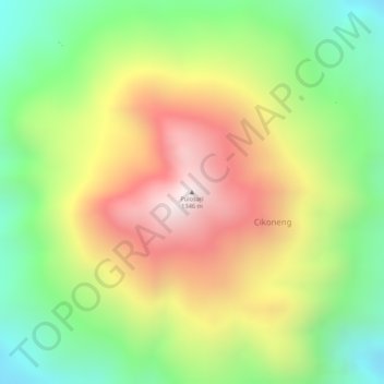
Name: Pulosari topographic map, elevation, terrain.
Location: Pulosari, Pandat, Pandeglang, Banten, Java, 42271, Indonesia (-6.34171 105.97829 -6.34161 105.97839)
Average elevation: 910 m
Minimum elevation: 532 m
Maximum elevation: 1,316 m
Thank you for supporting this site ❤️
Make a donation
Make a donation
Gear up for your next adventure:
As an Amazon Associate, this site earns from qualifying purchases at no extra cost to you.