Geolocate

Santa Matilde topographic map

Click on the map to display elevation.

About this map

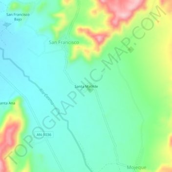
Name: Santa Matilde topographic map, elevation, terrain.

Location: Santa Matilde, San Francisco, Casma, Áncash, Perú (-9.53139 -78.25312 -9.49139 -78.21312)

Average elevation: 139 m

Minimum elevation: 79 m

Maximum elevation: 283 m

Gear up for your next adventure:

🧭GPS Tracker - Track your location in remote areas safely
👟Leg Gaiters - Keep debris, mud, and snow out of your boots
💡Compact LED Flashlight - Powerful and portable flashlight for outdoor use
🦶Hiking Shoe Insoles - Added support for high arches and long days on feet
Backpacking Tent - Lightweight tent for long-distance hiking trips

As an Amazon Associate, this site earns from qualifying purchases at no extra cost to you.