
Cerro Verde Pampa Churigua topographic map
Interactive map
Click on the map to display elevation.
About this map
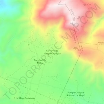
Name: Cerro Verde Pampa Churigua topographic map, elevation, terrain.
Average elevation: 3,173 m
Minimum elevation: 2,826 m
Maximum elevation: 3,566 m
Other topographic maps
Click on a map to view its topography, its elevation and its terrain.
Lipez
Bolivie > Cochabamba > Capinota > Santiváñez > Lipez
Lipez, Santiváñez, Capinota, Cochabamba, Bolivie
Average elevation: 2,570 m