Geolocate

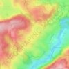
25650 topographic map

Click on the map to display elevation.

About this map

Name: 25650 topographic map, elevation, terrain.

Location: 25650, La Longeville, Pays-de-Montbenoît, Pontarlier, Doubs, Bourgogne-Franche-Comté, France métropolitaine, France (46.95265 6.36340 47.07871 6.52498)

Average elevation: 938 m

Minimum elevation: 755 m

Maximum elevation: 1,266 m

Other topographic maps

Click on a map to view its topography, its elevation and its terrain.
Gear up for your next adventure:

⛺Camping Tent - Weather-resistant tents suitable for 2 to 6 people
🎒Hiking Backpack - Lightweight and ergonomic backpacks for day hikes or multi-day treks
🧴Waterproofing Spray - Restore the DWR coating on jackets and tents
🥾Approach Boots - Comfortable boots for hiking and climbing approaches
🚲Heavy Duty Bike Lock - Secure your bike at the trailhead or during stops

As an Amazon Associate, this site earns from qualifying purchases at no extra cost to you.