
Thank you for supporting this site ❤️
Make a donation
Make a donation
Gear up for your next adventure:
As an Amazon Associate, this site earns from qualifying purchases at no extra cost to you.
Tizi topographic map
Click on the map to display elevation.
Thank you for supporting this site ❤️
Make a donation
Make a donation
Gear up for your next adventure:
As an Amazon Associate, this site earns from qualifying purchases at no extra cost to you.
About this map
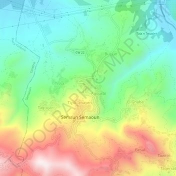
Name: Tizi topographic map, elevation, terrain.
Location: Tizi, Semaoun, Daïra Amizour, Béjaïa, 06020, Algérie (36.59506 4.80472 36.63506 4.84472)
Average elevation: 325 m
Minimum elevation: 53 m
Maximum elevation: 759 m
Thank you for supporting this site ❤️
Make a donation
Make a donation
Gear up for your next adventure:
As an Amazon Associate, this site earns from qualifying purchases at no extra cost to you.