
Make a donation
Gear up for your next adventure:
As an Amazon Associate, this site earns from qualifying purchases at no extra cost to you.
Washington Township topographic map
Click on the map to display elevation.
Make a donation
Gear up for your next adventure:
As an Amazon Associate, this site earns from qualifying purchases at no extra cost to you.
About this map
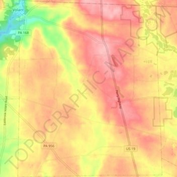
Name: Washington Township topographic map, elevation, terrain.
Average elevation: 381 m
Minimum elevation: 303 m
Maximum elevation: 425 m
Make a donation
Gear up for your next adventure:
As an Amazon Associate, this site earns from qualifying purchases at no extra cost to you.
Other topographic maps
Click on a map to view its topography, its elevation and its terrain.
East New Castle
United States > Pennsylvania > Lawrence County > Shenango Township
Average elevation: 318 m
Make a donation
Gear up for your next adventure:
As an Amazon Associate, this site earns from qualifying purchases at no extra cost to you.
Plain Grove
United States > Pennsylvania > Lawrence County > Plain Grove Township
Average elevation: 360 m