Geolocate

Magnolia topographic map

Click on the map to display elevation.

About this map

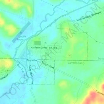
Name: Magnolia topographic map, elevation, terrain.

Location: Magnolia, Stark County, Ohio, United States (40.64492 -81.30423 40.66202 -81.27893)

Average elevation: 301 m

Minimum elevation: 285 m

Maximum elevation: 347 m

Other topographic maps

Click on a map to view its topography, its elevation and its terrain.

Mount Pleasant

United States > Ohio > Stark County

Average elevation: 352 m

Deer Creek

United States > Ohio > Stark County > Lexington

Average elevation: 319 m

Sippo Heights

United States > Ohio > Stark County > Massillon

Average elevation: 318 m

Lake Cable

United States > Ohio > Stark County

Average elevation: 340 m

North Industry

United States > Ohio > Stark County

Average elevation: 333 m

New Franklin

United States > Ohio > Stark County

Average elevation: 365 m

Gear up for your next adventure:

🥾Light Hiking Boots - Lightweight and comfortable boots for day hikes
🧥Softshell Jacket - Windproof and breathable jacket for hiking
🎒Hiking Daypack - Lightweight and durable backpacks for day trips and excursions
🥾Approach Shoes - Shoes designed for climbing approaches and rugged trails
🧦Crew Hiking Socks - Comfortable socks for long-distance hikes

As an Amazon Associate, this site earns from qualifying purchases at no extra cost to you.