Geolocate

San Pablo topographic map

Click on the map to display elevation.

About this map

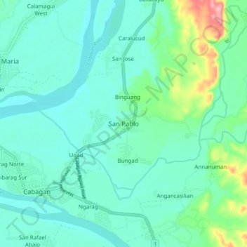
Name: San Pablo topographic map, elevation, terrain.

Location: San Pablo, Isabela, Cagayan Valley, 3329, Philippines (17.40850 121.75440 17.48850 121.83440)

Average elevation: 40 m

Minimum elevation: 9 m

Maximum elevation: 168 m

Other topographic maps

Click on a map to view its topography, its elevation and its terrain.

San Guillermo

Philippines > Isabela

Average elevation: 92 m

Magat Dam

Philippines > Isabela

Average elevation: 176 m

Gear up for your next adventure:

🥾Waterproof Hiking Boots - Essential footwear for rugged terrain and wet Canadian trails
🥘Camping Cookware Set - Compact nesting pots and pans for trail cooking
🥾Trekking Boots - Durable boots for long-distance trekking
🧥Waterproof Jacket - Lightweight rain jackets for hiking and outdoor activities
🛁Quick-Dry Microfiber Towel - Space-saving towel that dries rapidly on the move

As an Amazon Associate, this site earns from qualifying purchases at no extra cost to you.