Geolocate

Dayton topographic map

Click on the map to display elevation.

About this map

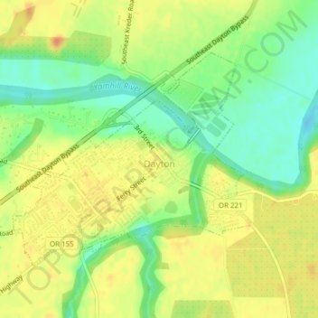
Name: Dayton topographic map, elevation, terrain.

Location: Dayton, Yamhill County, Oregon, United States (45.21197 -123.09384 45.23011 -123.06492)

Average elevation: 43 m

Minimum elevation: 21 m

Maximum elevation: 60 m

Other topographic maps

Click on a map to view its topography, its elevation and its terrain.

Amity Hills

United States > Oregon > Yamhill County > Amity

Average elevation: 108 m

Hopewell

United States > Oregon > Yamhill County

Average elevation: 62 m

Tetons

United States > Oregon > Yamhill County

Average elevation: 406 m

Gear up for your next adventure:

🧥Packable Rain Jacket - Breathable waterproof layer for unpredictable weather
🧢Sun Protection Cap - Breathable cap to protect from sun exposure
👟Trail Running Shoes - Agile footwear for fast-paced topographic exploration
🥾Lightweight Hiking Shoes - Comfortable shoes for day hikes
🧰Multitool Knife - Compact and versatile tool for outdoor use

As an Amazon Associate, this site earns from qualifying purchases at no extra cost to you.