
Thank you for supporting this site ❤️
Make a donation
Make a donation
Gear up for your next adventure:
As an Amazon Associate, this site earns from qualifying purchases at no extra cost to you.
Catequilla topographic map
Click on the map to display elevation.
Thank you for supporting this site ❤️
Make a donation
Make a donation
Gear up for your next adventure:
As an Amazon Associate, this site earns from qualifying purchases at no extra cost to you.
About this map
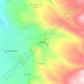
Name: Catequilla topographic map, elevation, terrain.
Location: Catequilla, Chambo, Chimborazo, 060116, Ecuador (-1.74784 -78.60073 -1.70784 -78.56073)
Average elevation: 2,966 m
Minimum elevation: 2,650 m
Maximum elevation: 3,353 m
Thank you for supporting this site ❤️
Make a donation
Make a donation
Gear up for your next adventure:
As an Amazon Associate, this site earns from qualifying purchases at no extra cost to you.