Geolocate

Montería topographic map

Click on the map to display elevation.

About this map

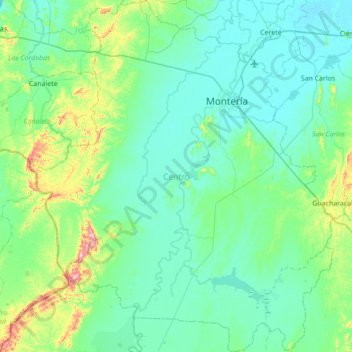
Name: Montería topographic map, elevation, terrain.

Location: Montería, Córdoba, RAP Caribe, Colombia (8.26308 -76.27881 8.94632 -75.66941)

Average elevation: 67 m

Minimum elevation: 4 m

Maximum elevation: 441 m

Other topographic maps

Click on a map to view its topography, its elevation and its terrain.

Tierra Santa

Colombia > Córdoba > Buenavista

Average elevation: 31 m

La Ye

Colombia > Córdoba > Sahagún

Average elevation: 122 m

Gear up for your next adventure:

🦶Hiking Shoe Insoles - Added support for high arches and long days on feet
🧰Survival Kit - Essential gear for emergencies in the wilderness
🌬️Windproof Camp Stove - Efficient cooking even on exposed mountain peaks
🎒Hiking Backpack - Lightweight and ergonomic backpacks for day hikes or multi-day treks
🧴Bear Spray Holster - Quick-access carry for essential Canadian wilderness safety

As an Amazon Associate, this site earns from qualifying purchases at no extra cost to you.