
Montredon topographic map
Click on the map to display elevation.
Montredon
Le nom de Mont-Redon vient plus vraisemblablement du collet (petite colline) qui dominait le quartier de Bonneveine. Ce collet était surmonté d’un château XIXe dans le style troubadour qui a été démoli dans les années 1960 pour être remplacé par un petit groupe d’immeubles. Ce collet calcaire est sans doute le reste d’une ile qui a été réunie à la terre par les atterrissements de l’Huveaune qui ont créé la plaine alluviale de Bonneveine. Le collet, d’une altitude d’environ 45m, est entaillé de nombreux fronts de carrière que l’on peut voir facilement sur les images aériennes.
About this map
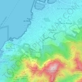
Name: Montredon topographic map, elevation, terrain.
Average elevation: 83 m
Minimum elevation: -2 m
Maximum elevation: 426 m
Other topographic maps
Click on a map to view its topography, its elevation and its terrain.
Arrête de Marseille
France > Provence-Alpes-Côte d'Azur > Bouches-du-Rhône > Marseille
Average elevation: 208 m
Mont Saint-Cyr
France > Provence-Alpes-Côte d'Azur > Bouches-du-Rhône > Marseille
Average elevation: 382 m
Sommet de l'Île Ratonneau
France > Provence-Alpes-Côte d'Azur > Bouches-du-Rhône > Marseille
Average elevation: 2 m
Sommet de l'Île Pomègues (Frioul)
France > Provence-Alpes-Côte d'Azur > Bouches-du-Rhône > Marseille
Average elevation: 4 m
Dalle du Chat
France > Provence-Alpes-Côte d'Azur > Bouches-du-Rhône > Marseille
Average elevation: 68 m
Dérivation de Saint-Barnabé du Canal de Marseille
France > Provence-Alpes-Côte d'Azur > Bouches-du-Rhône > Marseille
Maximin-Dominique Consolat, maire de Marseille de 1832 à 1843, décida en 1834 « quoi qu'il advienne, quoi qu'il en coûte » de faire venir à Marseille l'eau de la rivière la plus proche, la Durance, pourtant lointaine et séparée de Marseille par de nombreux chaînons montagneux (chaîne des Côtes,…
Average elevation: 109 m
Plage du Prado
France > Provence-Alpes-Côte d'Azur > Bouches-du-Rhône > Marseille
Average elevation: 11 m
Plage des Catalans
France > Provence-Alpes-Côte d'Azur > Bouches-du-Rhône > Marseille
Average elevation: 19 m
Parc de la Moline
France > Provence-Alpes-Côte d'Azur > Bouches-du-Rhône > Marseille
Average elevation: 110 m
La Nerthe
France > Provence-Alpes-Côte d'Azur > Bouches-du-Rhône > Marseille > La Nerthe
Average elevation: 174 m
Plage de la Pointe Rouge
France > Provence-Alpes-Côte d'Azur > Bouches-du-Rhône > Marseille
Average elevation: 22 m
Calanque du Cancèu
France > Provence-Alpes-Côte d'Azur > Bouches-du-Rhône > Marseille
Average elevation: 52 m
Maïre
France > Provence-Alpes-Côte d'Azur > Bouches-du-Rhône > Marseille
Mesurant 990 mètres d'est en ouest et 540 mètres du nord au sud, l'île Maïre culmine néanmoins à 141 mètres d'altitude à un sommet non nommé situé juste à l'ouest du pic des Gabians qui s'élève lui à 138 mètres d'altitude. Elle est totalement inhabitée et, hormis les gabians, la vie animale y…
Average elevation: 7 m
Les Trois Arches
France > Provence-Alpes-Côte d'Azur > Bouches-du-Rhône > Marseille
Average elevation: 159 m
La Pelouque
France > Provence-Alpes-Côte d'Azur > Bouches-du-Rhône > Marseille
Average elevation: 120 m
Parc Longchamp
France > Provence-Alpes-Côte d'Azur > Bouches-du-Rhône > Marseille
Average elevation: 57 m
Campagne Pastré
France > Provence-Alpes-Côte d'Azur > Bouches-du-Rhône > Marseille
Average elevation: 85 m
Roc de la Croix
France > Provence-Alpes-Côte d'Azur > Bouches-du-Rhône > Marseille
Average elevation: 179 m
Cirque des Walkyries
France > Provence-Alpes-Côte d'Azur > Bouches-du-Rhône > Marseille
Average elevation: 132 m
Fort Saint-Nicolas
France > Provence-Alpes-Côte d'Azur > Bouches-du-Rhône > Marseille
Average elevation: 26 m
Parc Billoux
France > Provence-Alpes-Côte d'Azur > Bouches-du-Rhône > Marseille
Average elevation: 32 m
Jardin de l'Hôtel de l'Abbaye
France > Provence-Alpes-Côte d'Azur > Bouches-du-Rhône > Marseille
Average elevation: 30 m
Rocher des Goudes
France > Provence-Alpes-Côte d'Azur > Bouches-du-Rhône > Marseille
Average elevation: 84 m
Parc Foresta
France > Provence-Alpes-Côte d'Azur > Bouches-du-Rhône > Marseille
Average elevation: 94 m
La Petite Aiguille
France > Provence-Alpes-Côte d'Azur > Bouches-du-Rhône > Marseille
Average elevation: 69 m
Glacier des calanques
France > Provence-Alpes-Côte d'Azur > Bouches-du-Rhône > Marseille
Average elevation: 49 m
barre de Mont Rose
France > Provence-Alpes-Côte d'Azur > Bouches-du-Rhône > Marseille
Average elevation: 48 m
Fort Saint-Jean
France > Provence-Alpes-Côte d'Azur > Bouches-du-Rhône > Marseille
Le fort Saint-Jean a disposé jusqu'en 1944 d'une échelle de marée en marbre dont la cote 0,329 m a servi de point zéro au nivellement général de la France et donc à toutes les altitudes données en France. L'échelle de marée a été détruite par le dynamitage et l'effondrement du fameux pont…
Average elevation: 19 m
Château de la Buzine
France > Provence-Alpes-Côte d'Azur > Bouches-du-Rhône > Marseille
Average elevation: 107 m
Vallon de la Croix noire
France > Provence-Alpes-Côte d'Azur > Bouches-du-Rhône > Marseille
Average elevation: 77 m