
Make a donation
Gear up for your next adventure:
As an Amazon Associate, this site earns from qualifying purchases at no extra cost to you.
Lichfield topographic map
Click on the map to display elevation.
Make a donation
Gear up for your next adventure:
As an Amazon Associate, this site earns from qualifying purchases at no extra cost to you.
About this map
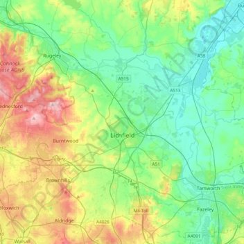
Name: Lichfield topographic map, elevation, terrain.
Location: Lichfield, Staffordshire, England, United Kingdom (52.58489 -1.96323 52.80779 -1.58629)
Average elevation: 103 m
Minimum elevation: 43 m
Maximum elevation: 241 m
Make a donation
Gear up for your next adventure:
As an Amazon Associate, this site earns from qualifying purchases at no extra cost to you.
Other topographic maps
Click on a map to view its topography, its elevation and its terrain.
Burton-on-Trent
United Kingdom > England > Staffordshire > East Staffordshire
Burton is about 109 miles (175 km) north west of London, about 30 miles north east of Birmingham, the UK's second largest city and about 23 miles east of the county town Stafford. It is at the easternmost border of the county of Staffordshire with Derbyshire, its suburbs and the course of the River Trent…
Average elevation: 69 m
Upper Tean
United Kingdom > England > Staffordshire > Staffordshire Moorlands
Average elevation: 175 m
Swan Bank
United Kingdom > England > Staffordshire > Newcastle-under-Lyme > Madeley Heath
Average elevation: 135 m
Make a donation
Gear up for your next adventure:
As an Amazon Associate, this site earns from qualifying purchases at no extra cost to you.
The Moss
United Kingdom > England > Staffordshire > Newcastle-under-Lyme > Madeley > The Moss
Average elevation: 122 m