
Lichfield topographic map
Click on the map to display elevation.
About this map
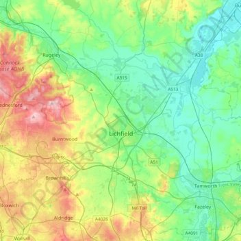
Name: Lichfield topographic map, elevation, terrain.
Location: Lichfield, Staffordshire, England, United Kingdom (52.58489 -1.96323 52.80779 -1.58629)
Average elevation: 103 m
Minimum elevation: 43 m
Maximum elevation: 241 m
Other topographic maps
Click on a map to view its topography, its elevation and its terrain.
Upper Tean
United Kingdom > England > Staffordshire > Staffordshire Moorlands
Average elevation: 175 m
Swan Bank
United Kingdom > England > Staffordshire > Newcastle-under-Lyme > Madeley Heath
Average elevation: 135 m
The Moss
United Kingdom > England > Staffordshire > Newcastle-under-Lyme > Madeley > The Moss
Average elevation: 122 m