
Yorkshire topographic map
Interactive map
Click on the map to display elevation.
About this map
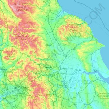
Name: Yorkshire topographic map, elevation, terrain.
Average elevation: 130 m
Minimum elevation: -1 m
Maximum elevation: 885 m
Other topographic maps
Click on a map to view its topography, its elevation and its terrain.
Asenby
United Kingdom > England > Harrogate
Asenby, Harrogate, North Yorkshire, Yorkshire and the Humber, England, United Kingdom
Average elevation: 25 m
Old Wives Gill
United Kingdom > England > Harrogate
Old Wives Gill, Harrogate, North Yorkshire, Yorkshire and the Humber, England, LS29 0EE, United Kingdom
Average elevation: 178 m
Ripley
United Kingdom > England > Harrogate
Ripley, Harrogate, North Yorkshire, Yorkshire and the Humber, England, United Kingdom
Average elevation: 86 m
Nova Scotia Wood
United Kingdom > England > Harrogate
Nova Scotia Wood, Church Street, Bilton-in-Ainsty with Bickerton, Harrogate, North Yorkshire, Yorkshire and the Humber, England, YO26 7NN, United Kingdom
Average elevation: 29 m