
Morvan topographic map
Click on the map to display elevation.
Morvan
It is the smallest mountain area in France in terms of landmass covered, as well as the lowest, with a maximum altitude of 901 metres (2,956 feet) at Haut-Folin.
About this map
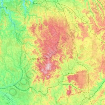
Name: Morvan topographic map, elevation, terrain.
Location: Morvan, Bourgogne – Franche-Comté, Metropolitan France, France (46.70550 3.61107 47.51240 4.54147)
Average elevation: 367 m
Minimum elevation: 139 m
Maximum elevation: 904 m
Other topographic maps
Click on a map to view its topography, its elevation and its terrain.
La Vieille Voie
France > Bourgogne – Franche-Comté > Haute-Saône > Corravillers
Average elevation: 593 m
Sous Les Coteaux de Charmo
France > Bourgogne – Franche-Comté > Côte-d'Or > Avot
Average elevation: 411 m
La Folie
France > Bourgogne – Franche-Comté > Yonne > Charny Orée de Puisaye > Saint-Martin-sur-Ouanne
Average elevation: 174 m
Moulin de la Ville
France > Bourgogne – Franche-Comté > Saône-et-Loire > Chagny
Average elevation: 219 m
Le Haut de la Beuille
France > Bourgogne – Franche-Comté > Haute-Saône > Fougerolles-Saint-Valbert
Average elevation: 372 m
Le Château du Bois
France > Bourgogne – Franche-Comté > Nièvre > Entrains-sur-Nohain
Average elevation: 245 m
Sur Ilots du Bas
France > Bourgogne – Franche-Comté > Haute-Saône > Renaucourt
Average elevation: 232 m
Les Loges de Vandenesse
France > Bourgogne – Franche-Comté > Nièvre > Saint-Honoré-les-Bains
Average elevation: 262 m
La Croix
France > Bourgogne – Franche-Comté > Saône-et-Loire > Saint-Sernin-du-Bois
Average elevation: 445 m
Le Reux
France > Bourgogne – Franche-Comté > Nièvre > Saint-Honoré-les-Bains > Tussy
Average elevation: 354 m
Mont Auxois
France > Bourgogne – Franche-Comté > Côte-d'Or > Alise-Sainte-Reine
Average elevation: 307 m
L'Enclose
France > Bourgogne – Franche-Comté > Haute-Saône > Servance-Miellin
Average elevation: 566 m
Jardins de l'Hôtel du Département
France > Bourgogne – Franche-Comté > Jura > Lons-le-Saunier
Average elevation: 299 m
Dardy
France > Bourgogne – Franche-Comté > Saône-et-Loire > Saint-Pierre-le-Vieux
Average elevation: 486 m
Bierre en Morvan
France > Bourgogne – Franche-Comté > Côte-d'Or > La Roche-en-Brenil
Average elevation: 385 m
Le Tertre
France > Bourgogne – Franche-Comté > Haute-Saône > Amont-et-Effreney
Average elevation: 504 m
Verdin
France > Bourgogne – Franche-Comté > Saône-et-Loire > Montagny-près-Louhans
Average elevation: 199 m
Château d'Estours
France > Bourgogne – Franche-Comté > Saône-et-Loire > Crêches-sur-Saône > Estours
Average elevation: 183 m
Saint-Valère
France > Bourgogne – Franche-Comté > Haute-Saône > Port-sur-Saône
Average elevation: 245 m
Abbaye en Grandvaux
France > Bourgogne – Franche-Comté > Jura > Grande-Rivière-Château
Average elevation: 956 m
Le Potin
France > Bourgogne – Franche-Comté > Nièvre > Châteauneuf-Val-de-Bargis
Average elevation: 300 m
Le Cailleret
France > Bourgogne – Franche-Comté > Côte-d'Or > Puligny-Montrachet
Average elevation: 276 m
La Roche d'Amont
France > Bourgogne – Franche-Comté > Haute-Saône > Haut-du-Them
Average elevation: 590 m
Les Creux Bréçons
France > Bourgogne – Franche-Comté > Saône-et-Loire > Toulon-sur-Arroux
Average elevation: 284 m
Auvillard
France > Bourgogne – Franche-Comté > Côte-d'Or > Saint-Victor-sur-Ouche
Average elevation: 438 m